Tuesday 23 August 2011

A Little Acknowledgement....

This final (planned) blog post will basically be a statement to acknowledge the fact that as I have never studied glaciers before I had no information about them and as such all the information included in my blog can be found on the internet (therefore none of it is my own). Predominantly I used two great sites for the vast majority of my posts (links can be found below), as well as many others sites for photos, diagrams, videos, quizzes and general information. The two main links that I used are:


(Great for all aspects of glaciers and other geography topics)

http://www.glaciers.pdx.edu/Projects/LearnAboutGlaciers/MRNP/Basics00.html 
  
(Another great site, less variety of information than the first but great detail on certain aspects of glaciers and bright interesting diagrams)

Ice Sheets

Due to their tremendous size (over fifty thousand square kilometres) and the need for a very cold climate these glacial features are only able to form in two areas of the world, those being Greenland and Antarctica.

The Antarctic Ice Sheet

Due to the continuing arrival of mass snow for the last 750,000 years, the Antarctic ice sheet is the largest single ice mass on earth, with a thickness of 4,200 metres in some areas. Covering almost fourteen million square kilometres it is inevitable that it swamps the majority of the Antarctic landscape with only the Transantarctic Mountains protruding through the sheet. The area itself is home to approximately thirty million cubed kilometres of ice, therefore storing an estimated ninety percent of the world’s fresh water, with the possibility of sea levels rising by seventy metres if the ice sheet should melt. 


Ice Caps


What are they? 

These are basically large sheets of ice covered in snow which feed the glaciers along their perimeter. Covering up to fifty thousand square kilometres, they can be broken up by outcrops of rock which are often the only navigational points around. Ice caps are found in both high and low altitudes although predominantly in northern regions of the world such as Norway, with their perimeters being surrounded by deep, steep sided valleys (often containing fast flowing glacial streams), lakes (fed by meltwater) and low shrub growth such as grasses and dwarf silver birch trees. The valleys themselves are often the only routes into such areas and as such journeys can take a long while with detours and back tracking necessary to find a suitably safe route. Any ice cap bigger than fifty thousand square kilometres is classed as an ice sheet (which shall be discussed in the next post), with the edges of many ice caps providing evidence of previous glaciation such as glacial lakes. An example of an ice cap is that of the Svartisen Ice Cap in northern Norway.


Monday 22 August 2011

Suncups, Piedmont Glaciers, Ribbon Lakes and Barren Zones

Suncups 

These are small depressions on the surface of the snow (or firn) created when the sun melts the snow and subsequently the snow evaporates.


Piedmont Glaciers 

These occur when steep valley glaciers flow onto flat plains, spreading out into a fan or bulb shape (lobes). An example of this is the Malaspina Glacier in Alaska, which is the largest piedmont glacier in the world due to having a width of forty miles. Upon leaving the mountain valleys it covers five thousand square kilometres of coastal plain.


Ribbon Lakes

These are formed by glaciers that increasingly deepen sections of the valley floor (often when the glacier is extending or compressing). This means that when the glacier retreats the deepened areas become filled with meltwater thus developing into lakes. These remain thousands of years after the glacier has totally melted away with subsequent streams and precipitation keeping them filled with water. An example of a ribbon lake is that of Llyn Peris (North Wales), with ‘Llyn’ being the welsh word for ‘lake’. The Lake District is a key example of how these lakes characterise an area. 

 Diagram of the various aspects of a ribbon lake

Llyn Peris

Barren Zone

This is the bare rock and ground that is uncovered around the margins of a glacier when it is retreating. These areas will often be smooth with no soil or vegetation covering, although may contain fresh moraine.

 Barren zone at the snout of a glacier


Tidewater Glaciers


Basically, these are glaciers that flow out into the sea. Due to having no support from the ground, tidewater glaciers are unable to sustain their weight and as such pieces often break off into the water (known as calving), therefore creating icebergs. The majority of tidewater glaciers calve above the ice, thus creating huge splashes as the iceberg lands in the sea. Occasionally however, they calve underneath the water if the water is deep enough, with this often being identified by an iceberg shooting up into the air, like an armband would in a swimming pool.

Similarly to land glaciers, tidewater glaciers advance, pushing moraine in front of them, although this occurs under the water and is commonly known as a moraine shoal. This moraine shoal protects the glacier from deep tidal water although when the glacier begins to retreat from the moraine shoal, the deep water is unable to support it (as stated earlier) and as such calving will dramatically increase, further intensifying its rate of retreat until the glacier is small enough to once again support itself. At this point the calving will slow, and the tidewater glacier will again begin to advance, once again creating a new moraine shoal.

An example of a tidewater glacier is that of the Hubbard Glacier in Alaska. Alaskan tidewater glaciers often terminate vertically, with ice above the water rising to two to three hundred feet and stretching beneath the water up to a thousand feet.

The diagram below is a great one to really show how the process occurs and could easily be given to students to help them understand the process better (with perhaps the process being explained first as a drawing on the board).


Sunday 21 August 2011

Glacial Ecosystems


Glaciers can be of great importance to surrounding ecosystems, with native American species of fish and amphibians such as Bull Trout, Coastal Cutthroat Trout and Tailed Frogs using glacially fed streams as key habitats. Glacially fed streams are different to those that flow from ice-free valleys due to the fact that glaciers melt a lot in warm summers (therefore generating lots of cool meltwater) and provide little water during wet winters. This therefore means that there is only a small level of annual variation in streamflow of glacial streams as opposed to non-glacial streams which tend to dry up in summer. Additionally, the glacial flour that occurs in glacial meltwater provides key nutrients for aquatic microbial life, although negatively it does reduce sunlight levels within the stream, therefore affecting some aquatic plants and animals (thus providing a very different habitat to non-glacial streams). As a glacier recedes (in the case of climate change) new habitats are provided where a glacier once lay.

 Glacial Flour

Saturday 20 August 2011

A Few Extra Terms

Eskers

These are ridges of well sorted sand and gravel several kilometres long and up to thirty metres in height, that are created by water that runs within tunnels in and underneath a glacier. The amount of rock debris in the ice, as well as the speed in which the sediment is delivered to the tunnel from upstream determines the amount of sediment in the esker, with it usually consisting of between pebble and cobble size material. When a glacier retreats the debris is deposited from the channel of water and onto the land where it forms a linear mound that is parallel to the path of the original glacial river. Eskers tend to form at the terminal zone of glaciers where the ice moves more slowly and can be singular, or can contain tributary eskers. The path of eskers tends to be governed by water pressure in relation to overlying ice, with the general pressure of the ice allowing eskers to run in the direction of glacial flow (even uphill) whilst forcing them into valleys or river beds to keep them in the lowest possible points (even if this means allowing them to deviate from the glacial path). This therefore produces the wider eskers which roads and so on can be built upon.
 
An example of some eskers are:
  • Uppsalaåsen in Sweden which runs for 156 miles 
  • Kemb Hills in Scotland which is 5km long
  •  Mason Esker in the USA which is 22 miles long
  •  Thelon Esker in Canada which is approximately 500 miles long
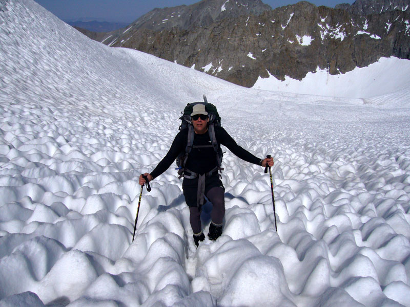
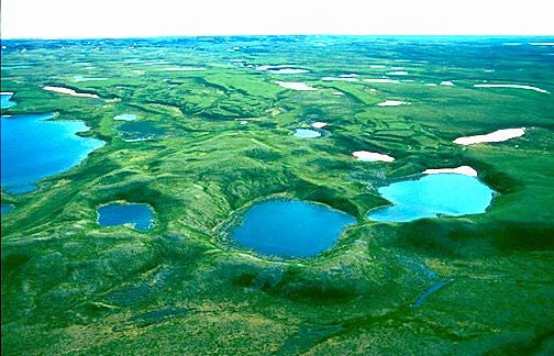
Kettle Lakes

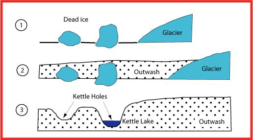
These form when glaciers recede. As this happens it is possible for blocks of ice to break off the glacier and remain in place. With the continual recession of the glacier there comes an increase in meltwater that carries debris which flows down to the block of ice, therefore beginning to form around its edge. When the partially buried ice-blocks melts, the surrounding debris falls into the hole (without filling it completely) therefore leaving a depression within the land known as a kettle hole, with most kettle holes being no more than two kilometres wide and ten metres deep. As these depressions begin to fill with water from streams and rivers they are known as kettle lakes. If however they fill with water from precipitation or the ground water table they are classed as a kettle pond or kettle wetland. If a kettle pond is not affected by the ground water table but fills only with water from precipitation then it will usually become dry during summer months and as such will be classed as ephemeral. If however the water within a kettle becomes acidic due to decomposing organic matter then it will instead be classed as a kettle bog or kettle peatland. When numerous kettle holes occur, ridges and mounds begin to form between them which resemble glacial kame. 

Kettle lakes can be found all over the world such as in:
  • Canada (Kettle Point) 
  • England (Hatchmere) 
  • Scotland (Loch Fergus) 
  • Germany 
 How kettle lakes are formed

Kettle lakes

 Truncated Spurs

This is caused when a river initially erodes vertically to create a ‘V’ shaped valley. During erosion the river meanders around the hardest rock and erodes through the softest, therefore creating interlocking spurs. When a glacier then flows down a former river valley it is unable to travel around the spurs as the river was able to do and as such it follows a straighter course by eroding straight through their tips, therefore forming truncated spurs. Hanging valleys are often found between truncated spurs as they join the main glacial valley from the side.

The top image shows interlocking spurs. The lower image shows how they have changed into truncated spurs.

Kames

Kames are mounds of sediment (specifically sorted into just sand and gravel) that are deposited along the snout of a receding or stationary glacier. The sediment continues to build up as the ice melts with further sediment being deposited on top of existing sediment therefore creating mounds. Kame terraces however are formed when troughs are created at the side of a glacier due to the warm valley rock in the summer melting the ice, with meltwater streams carrying, sorting and depositing the sediment. Kame deltas occur however when streams carry sediment to glacial lakes and during this process build the kame deltas upon the ice. When the glacier melts, the kame delta will collapse upon the top of the land, therefore often forming the ‘kame and kettle’ topography. The difference between a moraine and a kame is that the sediment in a kame is carried by water and is therefore sorted into sand and gravel whereas moraines consist of all types of debris due to being carried by ice. 

 Glacial kame

Kame terrace